Destinations · Second Trip

Hidden Gems in Türkiye

Eight places for the second trip, after Istanbul, Cappadocia and the coast.

Show Me Türkiye October 2026 8 min read

This page is for the second trip. If you have done Istanbul, Cappadocia and the coast, these eight places are where we would send you next. "Hidden" here does not mean unknown: every one of them is familiar to Turkish travellers. It means outside the circuit most international visitors follow on a first trip.

The rule cuts both ways. Cappadocia, Pamukkale, Ephesus, Ölüdeniz, Göbekli Tepe, Mardin and Nemrut are excluded however good they are; they belong to our top 10 places to visit in Türkiye, which is the first-trip list. And a quiet place does not qualify just for being quiet. Each entry below has to offer something the first trip cannot: a landscape, a building or a kind of town you will not find on the classic route.

The eight, grouped by the trip they suit: Kastamonu and Amasya in northern Anatolia; Macahel and Şavşat in Artvin; the Cilo Mountains of Hakkari; Ani, Divriği and Kemaliye in the east; and the Phrygian Highlands on the western plateau.
§
01Kastamonu and the Küre canyons

Kastamonu and the Küre canyons.

1 min read
  • Why it is here: An intact Ottoman town and two canyons, Horma and Valla, an hour apart
  • Location: Northern Anatolia, inland from the western Black Sea coast
  • Best season: June to September for canyons; autumn for forest colour
  • Access: Domestic airport in Kastamonu; a car is needed for the canyons around Pınarbaşı

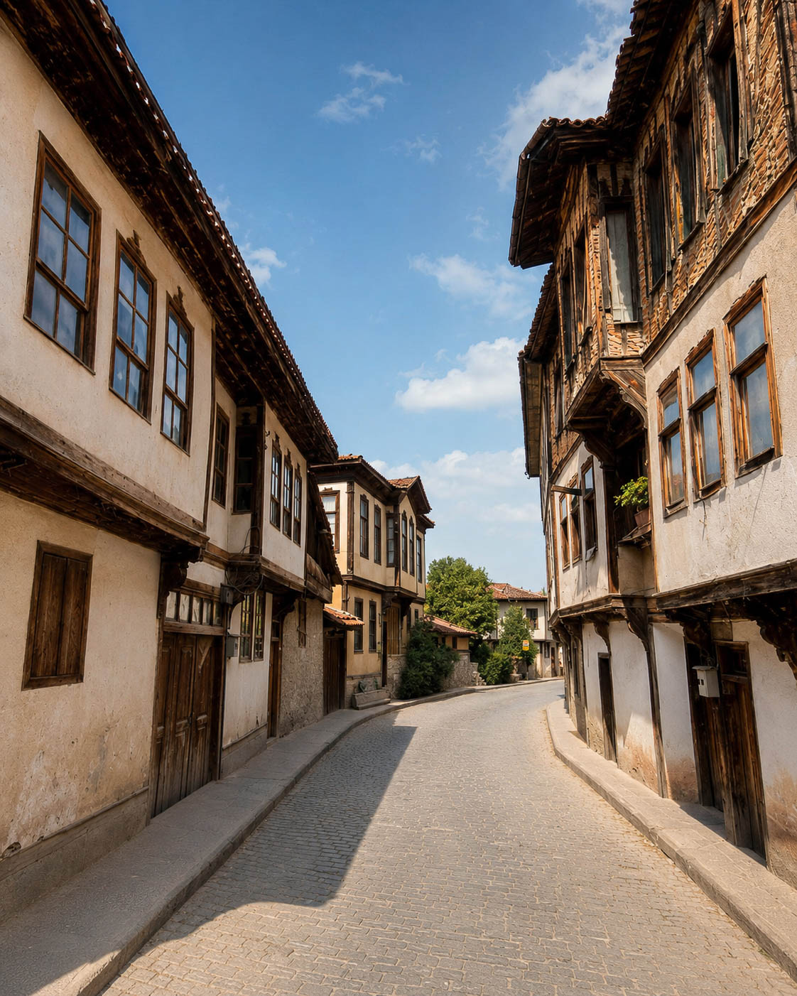
Kastamonu is one of the most intact Ottoman towns in the country: a castle on a rock above streets of timber-framed konak houses, a working bazaar and a cluster of early mosques and hans. Most international visitors who come this far stop at Safranbolu, two hours west, and turn back. Kastamonu has the same architecture, a living town around it and fewer coach parties.

Timber-framed Ottoman konak houses on a street in Kastamonu
Timber-framed konaks in Kastamonu’s old town.

The bigger reason is north of town, in the Küre Mountains. Horma Canyon has a wooden walkway of about 3 km fixed to the rock wall, an easy walk that ends near Ilıca Waterfall. Valla Canyon is the opposite: a gorge so deep and sheer that only equipped teams go inside, but a viewing terrace on the rim lets anyone look down into it.

Allow two to three days: one for the old town, one or two for the canyons and the Black Sea coast at Gideros. Our Kastamonu guide covers all eight anchors in detail.

The Kaçkar range, which runs east from Rize into Artvin.
02Macahel and Şavşat, Artvin

Macahel and Şavşat, Artvin.

1 min read
  • Why it is here: Türkiye's first UNESCO biosphere reserve, painted wooden mosques and forest lakes
  • Location: Northeastern Black Sea, on the Georgian border
  • Best season: June to October; September and October for autumn colour at Karagöl
  • Access: Rize-Artvin airport or Trabzon; a car is essential, some lake roads are partly unpaved

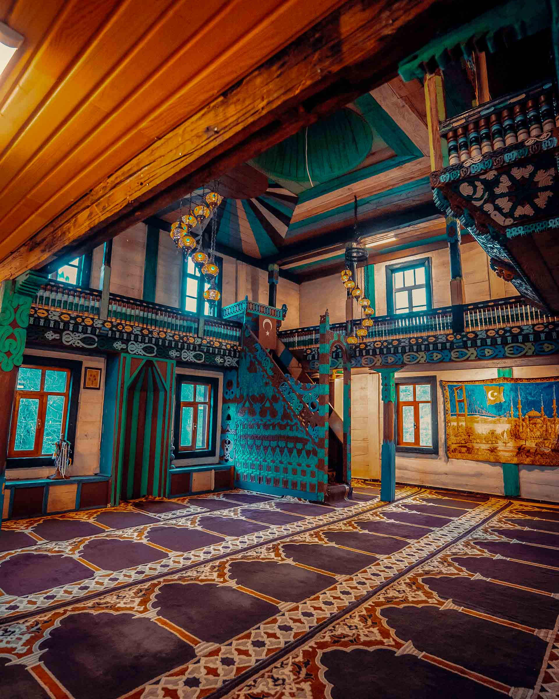
Artvin is the corner of the Black Sea that the Trabzon and Rize circuit usually stops short of. Macahel, the old name for the Camili valley in Borçka, is Türkiye's only UNESCO biosphere reserve: a valley of Colchic forest closed in by mountains and by Georgia on the far side. Its villages keep timber mosques with painted interiors, like the one at İremit, and the valley is known for its pure Caucasian honeybee.

Painted timber interior of the İremit mosque in the Macahel valley, Artvin
The painted wooden interior of the İremit mosque, Macahel.

Further east, Şavşat holds Karagöl, a dark landslide-dammed lake (heyelan gölü) inside the Karagöl-Sahara National Park, ringed by forest that turns orange in autumn, and the medieval Georgian church at Tibeti. The roads are slow and the weather is wet; that is the price of a forest this green.

Choose Artvin over Rize if you already know Uzungöl and want the same Black Sea forest on a quieter circuit, where village life sets more of the pace than tour itineraries do.

For the full province see our Artvin guide and the longer Artvin travel story. To combine it with Rize and Trabzon, the Black Sea Highlands route is the obvious frame.

§
03The Cilo Mountains, Hakkari

The Cilo Mountains, Hakkari.

1 min read
  • Why it is here: Türkiye's largest glaciers and its second-highest peak, in a national park since 2020
  • Location: Far southeast, on the Iraqi and Iranian borders
  • Best season: July to September
  • Difficulty: High. Unmarked terrain; go with a local guide
  • Access: Via Yüksekova or Van; conditions change, so confirm with the Hakkari governorate first

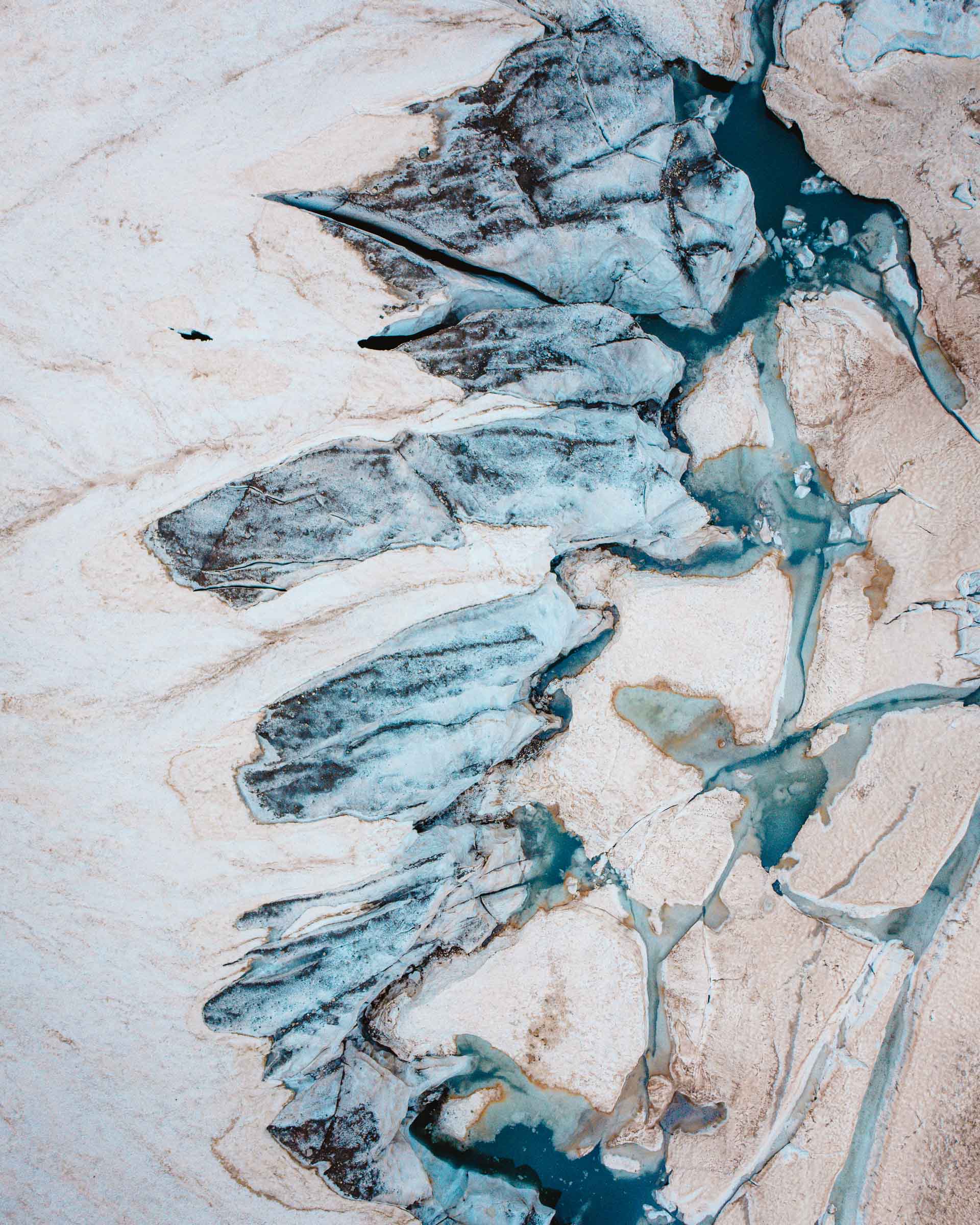
The Cilo and Sat ranges hold some of the highest ground in Türkiye. Reşko (Uludoruk) is the country's second-highest peak, at about 4,135 m, and the glaciers beneath it are among the largest in the country. The area was declared the Cilo-Sat Mountains National Park in 2020. Below the ranges, the Great Zap cuts a gorge of real scale through the province, and the Cennet Cehennem valley north of Hakkari city shows the contrast in a single drive.

Aerial view of glacier ice and meltwater in the Cilo Mountains
Glacier ice in the Cilo Mountains, among the largest in Türkiye.

This is the most demanding entry here, and it should not be added to a trip casually. Trails are not marked, the high roads open only in summer, and nights are cold even in August. Access rules in border areas can change at short notice: check the current position with the Hakkari governorate close to your dates, and travel with a local guide who knows the area.

Hakkari is not a detour from another trip. It is the trip.

Start with our Hakkari guide and the Hakkari travel story, which has the practical notes and our films from the region. For how Cilo compares with Türkiye’s other mountain regions, see our hiking guide.

§
04The Phrygian Highlands

The Phrygian Highlands: Eskişehir to Afyonkarahisar.

1 min read
  • Why it is here: Rock-carved Phrygian monuments in open steppe, with the volcanic geology but not the crowds
  • Location: Western Anatolian plateau, between Eskişehir, Kütahya and Afyonkarahisar
  • Best season: April to June, September to October
  • Access: Both cities are on main roads and rail; a car is needed for the valley

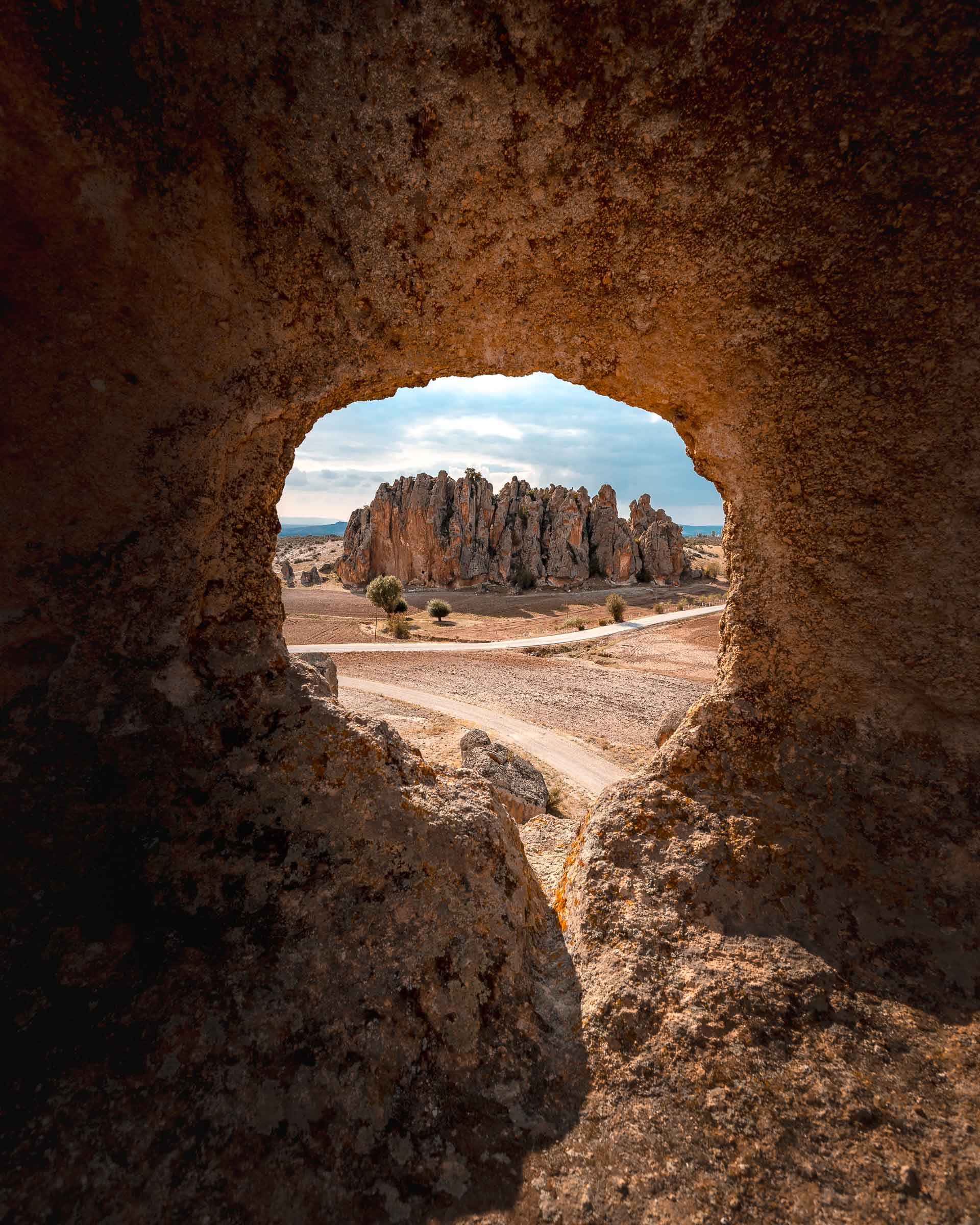
Long before the Romans, this plateau was the heartland of the Phrygians, the kingdom remembered through King Midas. They left their mark in soft volcanic tuff: carved rock facades, altars and tombs scattered across a landscape of pale outcrops. The best known is the monumental facade at Yazılıkaya, often called Midas City, south of Eskişehir. Around İhsaniye near Afyonkarahisar, rock-cut settlements such as Ayazini add early Christian cave churches.

Tuff outcrops in the Phrygian Valley seen through a rock-cut opening
Rock-cut chambers and tuff outcrops in the Phrygian Valley.

It is sometimes described as a quieter Cappadocia, and the geology is related. The experience is different: no balloons, few facilities, more driving between sites, and long stretches where yours is the only car. Bring food and water for the day.

Base in Eskişehir for the northern sites and the Odunpazarı old town, or in Afyonkarahisar for Ayazini, the castle rock and the 13th-century wooden Ulu Cami, part of the UNESCO-listed group of medieval wooden hypostyle mosques of Anatolia.

§
05Ani, Kars

Ani, Kars.

1 min read
  • Why it is here: A medieval Silk Road capital on an empty border plateau, UNESCO-listed since 2016
  • Location: Northeast, about 42 km from Kars, on the Armenian border
  • Best season: May to October; winter is severe
  • Access: Fly or take the train to Kars, then a car or taxi to the site

Ani was a medieval city on a branch of the Silk Road and, in the 10th and 11th centuries, a capital of the Bagratid Armenian kingdom. Today its churches, walls and mosque stand on a triangular plateau above the gorge that forms the border, with almost nothing modern in sight. UNESCO inscribed it as a World Heritage Site in 2016.

Ephesus shows a city restored; Ani shows one left to the wind. It is one of the main reasons second-trip travellers make it to Kars, and it pairs naturally with the Doğu Ekspresi (Eastern Express), whose line ends in Kars. Our Erzurum guide covers the train and the city halfway along the line.

§
06Divriği, Sivas

Divriği, Sivas.

1 min read
  • Why it is here: One building: carved stone portals with no real parallel in Anatolia
  • Location: Central-eastern Anatolia, Sivas province
  • Best season: May to October
  • Access: Road or rail from Sivas; best built into an east–west journey

Divriği is a small town with one reason to visit, and it is enough. The 13th-century Great Mosque and Hospital was among the first sites in Türkiye to join the UNESCO World Heritage List, in 1985, for its carved stone portals. After a long restoration it reopened to visitors in 2024.

Give it half a day. The town lies on the Sivas–Erzurum railway, so it can be a deliberate stop on an eastern rail journey rather than a dead-end drive.

§
07Kemaliye and the Dark

Kemaliye and the Dark Canyon, Erzincan.

1 min read
  • Why it is here: A road hand-cut through a Euphrates gorge, ending at a stone-and-timber town
  • Location: Western Erzincan, on the upper Euphrates
  • Difficulty: Narrow road, unlit tunnels; drive slowly and in daylight
  • Access: Road only; Erzincan is the nearest city with air and rail links

Kemaliye is a quiet town of stone and timber houses above a gorge of the Euphrates, Karanlık Kanyon (the Dark Canyon). The road through the canyon, known as the Taş Yol, was cut into the rock by local people over more than a century, about 7 km with dozens of short tunnels. It is now the main reason people come, and it is on Türkiye's UNESCO tentative list along with the town.

Drive it once in each direction; the views change. May to October is the usual driving season. Check road and weather conditions locally before going, especially early or late in the season.

§
08Amasya

Amasya.

1 min read
  • Why it is here: Royal Pontic tombs cut into the cliff above a river lined with Ottoman houses
  • Location: Inland central Black Sea region
  • Best season: April to June, September to October
  • Access: Road from Samsun (nearest major airport) or Tokat

Amasya sits in a narrow valley of the Yeşilırmak river. On one bank, timber Yalıboyu houses line the water; above them, the rock-cut tombs of the Pontic kings are carved into the cliff of Mount Harşena, lit at night. The ensemble is on Türkiye's UNESCO tentative list. The town was also a training ground for Ottoman princes, and its mosques and medreses reflect it.

One full day is enough for the town, two if you climb to the castle. It combines well with Kastamonu on a northern Anatolia loop.

§
09How to combine them

How to combine them.

1 min read

These places do not belong in one trip. Choose the region first, then the places.

TripPlacesTimeEffort
NorthKastamonu, Amasya4–5 daysEasy
Black Sea eastMacahel, Şavşat3–4 daysModerate
Eastern railKars and Ani, Divriği, Kemaliye6–8 daysModerate
Western plateauPhrygian Highlands2–3 daysEasy
High mountainsCilo, HakkariDedicated tripHigh

If you have one week and like towns, take the north. If you want landscape and can drive slow roads, take Artvin. If you want the train and the ruins, take the east, and use the Eastern Heritage route for the southeast circuit beyond it. If you have a weekend from Istanbul or İzmir, take the Phrygian Highlands. Hakkari is a separate decision, made with a guide.

For transport between regions, see getting around Türkiye. For seasons across the country, see when to visit Türkiye.

Show Me Türkiye
Written by
Show Me Türkiye Editorial
Field notes, routes, and city guides from across Türkiye. Last checked October 2026.
Halil BekarReviewed by Halil Bekar, founder of Show Me Türkiye
Your first trip?

Start with the classics.

If this is your first visit to Türkiye, begin with the ten places that explain the country.

Top 10 places →